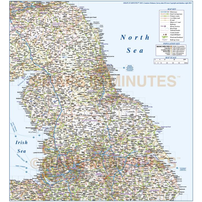
North England County Road & Rail map with insets @500,000 scale
Large up-to-date, highly detailed, 100% editable fully layered vector road map. Suitable for use up to any size. All text is editable font text. Projection matches Ordnance Survey data and co-ordinates.
Contains 1st level admin boundaries and fills as separate objects so can be used as either a political map, a road map or a combination of either.
North England 1st level Political Road & Rail Map 500,000 scale in layered Illustrator formats
Large up-to-date, highly detailed, 100% editable layered vector map. Suitable for use up to any size. All text is editable font text. Projection will match Ordnance Survey data and co-ordinates. Contains 1st level admin boundaries and fills so can be used as either a political map, a road map or a combination of either.
Layers include: Coastlines, county boundaries, county fills, county insets. Settlements layered by population. Road layers include Motorways (including motorway junctions and service stations) Primary routes and 'A' roads (including dual carriageways)), B roads, C and minor roads, comprehensive road numbering, railways, airports and airport names. Physical features include urban areas, forest and woodland, rivers and river names, lakes and lake names, island, bay and headland names, spot heights and symbols.
Formats: Available in Illustrator CS1, CS3, CS4 and CS6 (for use with Illustrator CS6/CC) or Adobe Acrobat Editable PDF 6.0 format on request. Our maps in PDF 6.0 format are fully layered within Acrobat but can still be opened and edited in Illustrator CS4 -CS6 while retaining full layering with 100% editability.
Map dimensions: 12.9" D x 11.8" W (32.7cm D x 29.9cm W)
Extracted Document sizes: Illustrator CS: 13.5Mb Acrobat PDF: N/A
Licence: Please click on the Licence tab to download and print the lifelong licence for this product.
How to download: You will be able to download by logging into Your Account where you can check the status and details of orders (including applicable Product End User Licence). You can download product purchases for a period of 10 days from date of purchase.
Please note: Product purchases and invoices are downloadable only and are not sent to any postal address
Authors notes: This stunning map is updated and re-styled for 2015 and is the most highly detailed editable regional mapping available off the shelf. It will match Ordnance Survey co-ordinates and data. A total re-draw has gone into creating what we believe is the best 500,000 scale mapping you can buy today and use immediately. We know OS data is freely available but creating a working map of this detail, flexability and quality would far outway in hours taken compared to purchasing this map.
Also available for purchase are sets of British Isles map sections, please see our British Isles Map Collections category. This style map is available as a complete British Isles County, road & rail map in Illustrator CS format. Click Here to visit whole map page. If you would like a relief map created to your custom boundaries this can be ordered. Please Contact Us for a quote or give us a call.
| Licence | Lifelong |
|---|