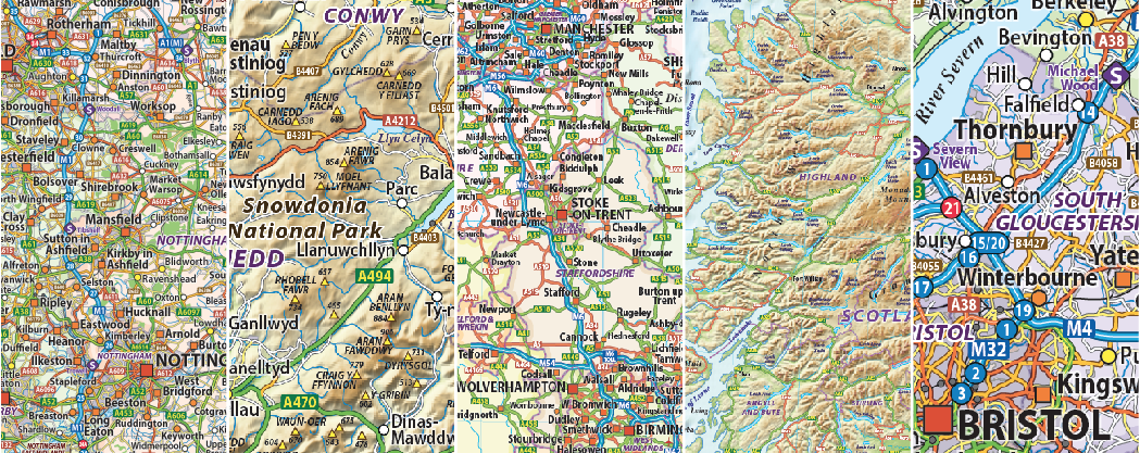
British Isles / UK Maps

Buy Online Highest Quality Digital British Isles/UK Map Products in Illustrator Editable Vector Format, fully layered and up-to-date.
This is the place to buy a UK Map online. Our British Isles Map / UK Map categories offer a comprehensive selection of up-to-date vector maps, available with a choice of either Political UK Map with Countries, UK Maps with Counties, complete British Isles Road Maps, UK Road Map and UK Regions Maps most with physical shaded relief options.
The physical shaded relief backgrounds are the highest quality placed tiff files. The maps are available in Adobe Illustrator vector layered format, all our maps are 100% editable in colour, fonts and styling, so you can use them as they are or modify them as you wish. You can purchase a British Isles map in different scales (sizes) and levels of detail.
We also offer UK Regional Maps with various levels of detail, please see below or click on the appropriate sub-categories.
Our eye-catching, highly detailed and accurate quality maps are ideal for business, education, advertising, television, film and government bodies.
We can also licence a British Isles Map for manufacturers of posters and printed map productions up to wall size, please contact us to discuss.
Using Ordnance Survey data sourcing we have completely re-drawn our 2024 mapping of the British Isles at an unprecedented level of detail and accuracy. We have also added a brand new range of high-resolution relief backgrounds. This unique product line brings a whole new level of Illustrator-based mapping to you, opening up new possibilities for design, print, apps and the web.
Custom areas from the complete databases can be cropped and supplied on request.
We have organised our large selection of British Isles/UK Map Products into easy-to-use navigation using Sub-Categories covering the following:
Whole UK Counties Maps
This is where you can buy a whole UK Map with Counties from 5m up to 1m scale. Our UK County Maps are superb quality & highly detailed and can be purchased in large or small sizes.
Whole UK Road Maps
This is where you can buy whole UK/British Isles Road Maps from 5m up to 1m scale. Our Road Maps are superb quality & highly detailed and can be purchased for large or small sizes. Large scale maps at 500k scale are fully layered and include comprehensive road detail of Motorways, Primary routes (incl. dual carriageways), A Roads, B Roads, C Roads and unclassified.
Also included are Railways with stations, County Boundaries and fills, settlements layered by population, airports, service stations, M’way junctions and road numbering, rivers and lakes, Physical names and spot heights plus much more. There are various levels of detail available from 500k to 5m scale
Whole UK Road Relief Maps
This is where you can buy a whole British Isles Map with roads and physical shaded relief from 5m up to 500k scale. Our Road Relief Maps are superb quality & highly detailed and can be purchased for large or small sizes. Large scale Maps at 500k scale are fully layered and include comprehensive road detail from Motorways, Primary routes (incl. dual carriageways), A Roads, B Roads, C Roads and unclassified.
Also included are Railways with stations, County Boundaries and fills, settlements layered by population, airports, service stations, M’way junctions and road numbering, rivers and lakes, Physical names and spot heights plus much more. There are various levels of detail available from 500k to 5m scale
Whole UK Relief Maps
When you just need a relief map you can buy whole UK/British Isles Maps with physical shaded relief from 5m up to 500k scale. Our Relief Maps are superb quality & highly detailed and can be purchased for large or small sizes. Detail includes Coastlines, rivers and lakes, Physical names plus more. There are various levels of detail available from 1m to 5m scale
Scotland Maps
Some of the most wonderful maps of Scotland are in this sub-category. This is where you can purchase from whole variety of Scotland Maps from 5m up to 500k scale. Political and Physical shaded relief options are available, many with the Northern Isles in position which we know many customers prefer. There are also a wide selection of Northern Isles Maps (Orkney and Shetland). They are superb quality & highly detailed and can be purchased for large or small sizes.
North England Maps
This is where you can purchase a variety of North England Maps from 1m up to 500k scale. Our North England Maps are superb quality & highly detailed. Political county and Physical shaded relief options are available.
Central England Maps
This is where you can purchase a variety of Central England Maps from 1m up to 500k scale. Our Central England Maps are superb quality & highly detailed. Political county and Physical shaded relief options are available.
East England Maps
This is where you can purchase a variety of East England Maps from 1m up to 500k scale. Our East England Maps are superb quality & highly detailed. Political county and Physical shaded relief options are available.
South East England Maps
This is where you can purchase a whole variety of South East England Maps from 1m up to 500k scale. Our South East England Maps are superb quality & highly detailed. Political county and Physical shaded relief options are available.
South West England Maps
This is where you can purchase a whole variety of South West England Maps from 1m up to 500k scale. Our South West England Maps are superb quality & highly detailed. Political county and Physical shaded relief options are available.
Wales Maps
Some of the most wonderful maps of Wales are in this sub-category. This is where you can purchase a whole variety of Wales Maps from 1m up to 500k scale. Our Wales Maps are superb quality & highly detailed. Political county and Physical shaded relief options are available.
