Scotland Regions Map, Illustrator AI CS & PDF formats, includes the Orkney Shetland Isles, 5m scale.
Small scale, up-to-date, highly detailed, 100% editable layered vector road and relief map in Illustrator CS format. Suitable for use up to any size. All text is editable font text. Projection will match Ordnance Survey data and co-ordinates. Contains 1st level admin boundaries and fills.
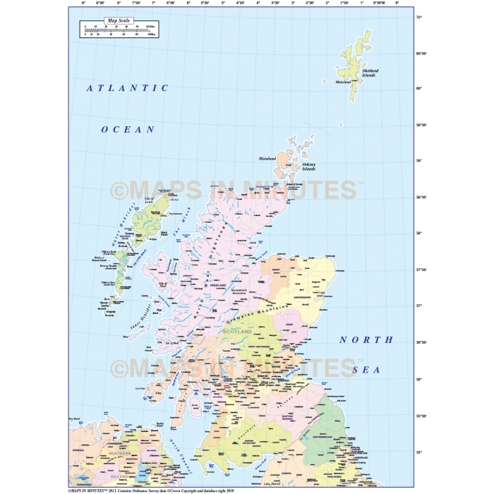
Scotland 1st level Region Political Map @5,000,000 scale in Illustrator vector format
Small scale, up-to-date, detailed, 100% editable layered vector map. Suitable for use from A4 to A3 but if used larger the line and text quality will remain sharp. All text is editable font text. Projection will match Ordnance Survey data and co-ordinates. Contains 1st level admin boundaries and fills.
Layers include: Coastlines, county boundaries, county fills (as separate objects). Settlements layered by population. Road layers include Motorways, Primary routes and 'A' roads, road numbering, airports and airport names. Physical features include rivers, lakes, island, bay and headland names.
Formats: Available Illustrator CS1 (for use with Illustrator CS1 to CS6 or later) or Adobe Acrobat Editable PDF 6.0 format. Our maps in PDF 6.0 format are fully layered within Acrobat but can still be opened and edited in Illustrator CS4 -CS6 while retaining full layering with 100% editability.
Map dimensions: 11.6" D x 8.3" W (29.3cm D x 21cm W)
Extracted Document sizes: Illustrator CS: 6.8Mb Acrobat PDF: 2.7Mb
Licence: Please click on the Licence tab to download and print the lifelong licence for this product.
How to download: You will be able to download by logging into Your Account where you can check the status and details of orders (including the applicable Product End User Licence). You can download product purchases for a period of 10 days from date of purchase. Download times will vary according to your Broadband speed.
Please note: Product purchases and invoices are downloadable only and are not sent to any postal address
Authors notes: This small scale region map is re-drawn and updated for 2013. Buy today and use immediately.
Also available for purchase are sets of British Isles maps, please see our British Isles Map Collections category.
If you would like a custom map created to your requirements please Contact Us for a quote or give us a call to discuss.
This map is also available with a range of high resolution relief backgrounds, click Here to see an example.
| Licence | Lifelong |
|---|