British Isles Basic Country map @5,000,000 scale
Small scale vector Country Map of the British Isles @5,000,000 scale in Adobe Illustrator or Acrobat PDF formats. Fully layered including coastlines and islands, country borders & fills (Scotland, England, Wales, Ireland & N. Ireland), country names, major rivers & lakes.
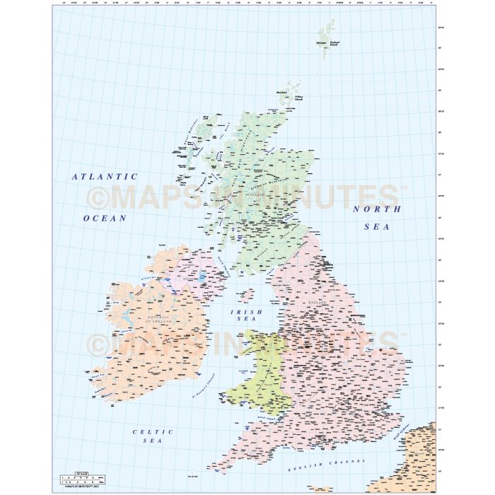
British Isles Country Map @5,000,000 scale with the Northern Isles in position
Small scale, fully layered, 100% editable Country map of the British Isles including the Northern Isles of Orkney and Shetland in position. Suitable for use from A4 to A3+, this map is more suited to use at larger sizes. For smaller use you may wish to consider the 5m scale EZRead version of this map. Being vector based it will always print to the highest quality. Projection matches Ordnance Survey data and co-ordinates.
Layers include: Coastlines, country boundaries, country fills (as separate objects). Settlements layered by population. Physical features include rivers and river names, lakes and lake names, mountain ranges, island names, bay and headland names, latitude & longitude.
Formats: Available in Illustrator CS1 (for use with Illustrator CS1 to CS6 or later) or editable Acrobat PDF formats.
Map dimensions: 10.06" D x 7.9" W (25.26cm D x 20.11cm W)
Extracted Document sizes: Illustrator CS: 16.3Mb Acrobat PDF: 5.3Mb
Licence: Please click on the Licence tab to download and print the lifelong licence for this product.
How to download: You will be able to download by logging into Your Account where you can check the status and details of orders (including the applicable Product End User Licence). You can download product purchases for a period of 10 days from date of purchase. Time to download will depend on your Broadband speed.
Please note: Product purchases and invoices are downloadable only and are not sent to any postal address
Authors notes: This basic map is updated for 2013. Also available for purchase are sets of British Isles maps, please see our British Isles Map Collections category.
| Licence | Lifelong |
|---|