Central England County Map plus Regular colour relief @1m scale
Royalty free, Large, up-to-date, highly detailed, 100% editable layered vector county and relief
map in Illustrator and PDF formats. Suitable for use up to almost any size.
All text is editable font text. Projection matches Ordnance Survey data and co-ordinates. Contains 1st level admin boundaries and fills so can be
used as either a political map, a relief map or a combination of either.
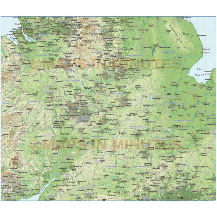
Central England County Map @1,000,000 scale plus a Regular colour relief background
ROYALTY FREE. Large up-to-date, highly detailed, 100% editable layered vector map. Suitable for use up to any size. All text is editable font text. Matches Ordnance Survey data and co-ordinates. Contains 1st level administrative boundaries and fills so can be used as either a political map, a relief map or a combination of both.
Layers include: Coastlines, county boundaries, Settlements layered by population. Physical features include rivers and river names, lakes and lake names, island, bay and headland names. Product includes a high resolution 300dpi relief background in regular colours as a placed (linked) tiff .
Formats: Available in Illustrator CS1 (for use with Illustrator CS1 to CS6 or later) or Adobe Acrobat Editable PDF 6.0 format. Our maps in PDF 6.0 format are fully layered within Acrobat but can still be opened and edited in Illustrator CS4 -CS6 while retaining full layering with 100% editability. Our relief tiff files are single layer.
Map dimensions: 8.88"wide x 10.37"deep (22.57cm x 26.34cm)
Extracted Document sizes: Illustrator CS: 36.8Mb plus 25Mb relief tiff file Acrobat PDF: 9.9Mb with 25Mb relief tiff file
Licence: Please click on the Licence tab to download and print the lifelong licence for this product.
How to download: You will be able to download by logging into Your Account where you can check the status and details of orders (including the applicable Product End User Licence). You can download product purchases for a period of 10 days from
date of purchase.
Please note: Product purchases and invoices are downloadable only and are not sent to any postal address
This style map is also available as a complete British Isles relief map in Illustrator CS format. Click Here to visit whole map page.
If you would like a relief map created to your custom boundaries this can be ordered.
Please Contact Us for a quote or give us a call to discuss.
| Licence | Lifelong |
|---|