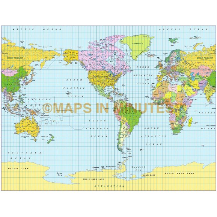
Gall Projection World map (US centric) @ 50M scale
£60.00
In stock
SKU
GALL50mUS
Product code: 234
ROYALTY FREE. Fully editable medium scale World map in a choice of vector formats.
You can turn the layers on or off, customise the lines, fills and text and add your own information to create your own styles.
Layers include: coastlines and islands, country borders & fills, country names, sea/ocean names, river names, rivers, major lake
ROYALTY FREE. Fully editable medium scale World map in a choice of vector formats.
You can turn the layers on or off, customise the lines, fills and text and add your own information to create your own styles.
Layers include: coastlines and islands, country borders & fills, country names, sea/ocean names, river names, rivers, major lakes, minor lakes, physical names, capital cities, major settlements, major airports plus latitude/longitude @ 10 & 5 degree intervals plus layered vector Sea contours. Suitable for use up to A3.
Map dimensions 45 inches D x 55 inches W (28.26 x 21.72 cm.)
Choose from Illustrator 5.5 (for use up to Illustrator 10), Illustrator CS (for use with Illustrator CS1, 2 or 3) or FreeHand 8. Choose Illustrator 5.5 to be compatible with CorelDraw 6 or later and Canvas 7 or later.
Usage: Technical suitable for whole-world reference maps. Note, however, that areas are not represented in their correct relative sizes, and the poles are shown as lines the whole width of the map, rather than as points. If these are problems, try Hammer. Gall Stereographic is a popular choice in the United Kingdom.Graphical suitable for world maps in brochures, but not suitable for displaying world statistics such as distribution of resources, vegetation, population, or industrial activity. For such maps, try Eckert IV, Mollweide, or Hammer.
ROYALTY FREE. Fully editable medium scale World map in a choice of vector formats. You can turn the layers on or off, customise the lines, fills and text and add your own information to create your own styles. Layers include: coastlines and islands, country borders & fills, country names, sea/ocean names, river names, rivers, major lakes, minor lakes, physical names, capital cities, major settlements, major airports plus latitude/longitude @ 10 & 5 degree intervals plus layered vector Sea contours. Suitable for use up to A3. Map dimensions 45 inches D x 55 inches W (28.26 x 21.72 cm.) Choose from Illustrator 5.5 (for use up to Illustrator 10), Illustrator CS (for use with Illustrator CS1, 2 or 3) or FreeHand 8. Choose Illustrator 5.5 to be compatible with CorelDraw 6 or later and Canvas 7 or later.
Usage: Technical suitable for whole-world reference maps. Note, however, that areas are not represented in their correct relative sizes, and the poles are shown as lines the whole width of the map, rather than as points. If these are problems, try Hammer. Gall Stereographic is a popular choice in the United Kingdom.Graphical suitable for world maps in brochures, but not suitable for displaying world statistics such as distribution of resources, vegetation, population, or industrial activity. For such maps, try Eckert IV, Mollweide, or Hammer.
Usage: Technical suitable for whole-world reference maps. Note, however, that areas are not represented in their correct relative sizes, and the poles are shown as lines the whole width of the map, rather than as points. If these are problems, try Hammer. Gall Stereographic is a popular choice in the United Kingdom.Graphical suitable for world maps in brochures, but not suitable for displaying world statistics such as distribution of resources, vegetation, population, or industrial activity. For such maps, try Eckert IV, Mollweide, or Hammer.
ROYALTY FREE. Fully editable medium scale World map in a choice of vector formats. You can turn the layers on or off, customise the lines, fills and text and add your own information to create your own styles. Layers include: coastlines and islands, country borders & fills, country names, sea/ocean names, river names, rivers, major lakes, minor lakes, physical names, capital cities, major settlements, major airports plus latitude/longitude @ 10 & 5 degree intervals plus layered vector Sea contours. Suitable for use up to A3. Map dimensions 45 inches D x 55 inches W (28.26 x 21.72 cm.) Choose from Illustrator 5.5 (for use up to Illustrator 10), Illustrator CS (for use with Illustrator CS1, 2 or 3) or FreeHand 8. Choose Illustrator 5.5 to be compatible with CorelDraw 6 or later and Canvas 7 or later.
Usage: Technical suitable for whole-world reference maps. Note, however, that areas are not represented in their correct relative sizes, and the poles are shown as lines the whole width of the map, rather than as points. If these are problems, try Hammer. Gall Stereographic is a popular choice in the United Kingdom.Graphical suitable for world maps in brochures, but not suitable for displaying world statistics such as distribution of resources, vegetation, population, or industrial activity. For such maps, try Eckert IV, Mollweide, or Hammer.
| Licence | Lifelong |
|---|