South East Asia Political map with regular colour relief option
NEW. Royalty Free. Detailed Political vector map
of Asia with 300dpi tiff relief background.
Includes all country fills and boundaries.
Available in Illustrator CS4, CS6 (for CC).
100% editable including font text.
For use from A3+ to A2 or larger.
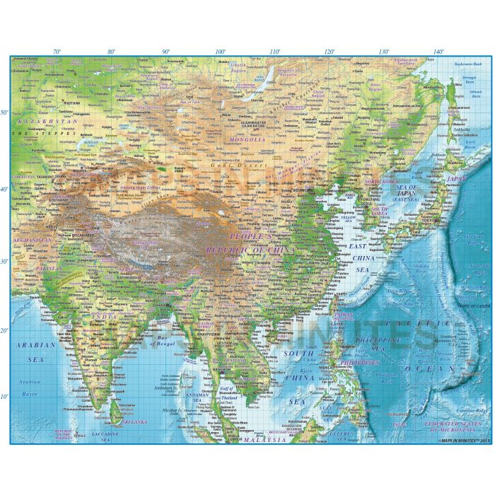
South East Asia Region Political vector map with regular colour relief option
Fully editable large scale Asia Political and relief map in a choice of Illustrator formats.
Layers include: Coastlines, country borders, country fills (as separate objects), capital cities, major settlements, country
names, sea/ocean names, rivers, river names, major lakes, lake names plus latitude/longitude @10, 5 and 1 degree intervals.
Tiff relief background plus land fill tiff mask.
Formats: Choose from Illustrator CS1, CS4, CS5 or CS6 (for CS6/CC) or Adobe Acrobat Editable PDF 6.0 format (on request).
Our maps in PDF 6.0 format are fully layered within Acrobat but can still be opened and edited in Illustrator CS4 -CS6
while retaining full layering with 100% editability.
Map dimensions: 11.04" D x 13.71" W (28.06 cm D x 34.83 cm W)
Extracted Document sizes: Illustrator CS: 6Mb (15Mb in CS1) plus 96.7Mb placed relief tiff Acrobat PDF: On request
Licence: Please click on the Licence tab to download and print the lifelong licence for this product.
How to download: You will be able to download by logging into Your Account where you can check the status and details of orders (including applicable Product End User Licence). You can download product purchases for a period of 10 days from date of purchase.
Please note: Product purchases and invoices are downloadable only and are not sent to any postal address
Authors notes: This map is new for 2015 and includes our latest high quality relief. Our relief backgrounds are contemporary and superbly detailed. The vector data matches up to the raster data very accurately allowing for a much larger, cleaner output. Text outline layers are employed to make the text read clearly even over the darker areas of the map. Suitable for use from A4 up to A2 size.
If you would prefer to purchase a set of Regions or World maps please visit our World Maps Collections category.
| Licence | Lifelong |
|---|