Australasia map with Land & Ocean floor contours Poster size
Detailed Political vector map of the Australasia continent including Indonesia, Malaysia, New Zealand and the Pacific island nations @10m scale including high resolution land and ocean floor contours. Available in Illustrator (for use with CS1 to CS6 and later). All map elements are 100% editable including font text. Change colour schemes very quickly and easily. For use from A4 to A1+. Royalty Free.
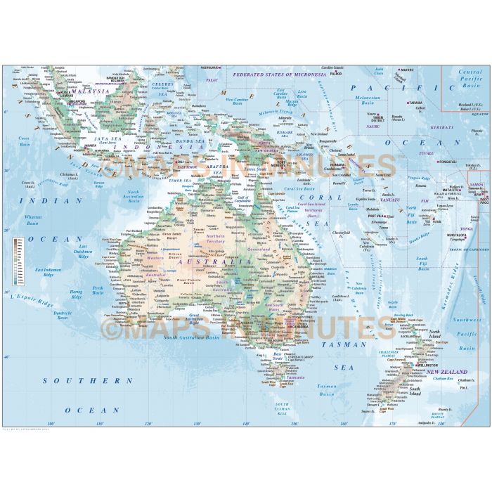
Australasia Continent map with high detail Land and Ocean floor contours @10m scale, Poster size
Fully editable, detailed, large scale Australasia vector layered map in Illustrator CS formats. This is a unique, quality map.
Layers include: Coastlines, country borders, Australia State boundaries, capital cities, cities over 1 million, major settlements, country names, sea/ocean names, ocean floor and land physical text, rivers/river names, major lakes/lake names, land contours (six levels), ocean floor contours (eight levels) plus latitude/longitude @10 and 5 degree intervals.
Formats: Choose from Illustrator CS1 (for use with Illustrator CS1 to CS5). We also offer an Illustrator 6 format for use with the latest versions in the drop down menu choice when ordering. Please choose the right one for your software.
Map dimensions: 31.2" D x 29.4" W (79.37cm D x 74.63cm W)
Extracted Document sizes: Illustrator CS: 22Mb Acrobat PDF: Can be supplied on request.
Licence: Please click on the Licence tab to download and print the lifelong licence for this product.
How to download: You will be able to download by logging into Your Account where you can check the status and details of orders (including the applicable Product End User Licence). You can download product purchases for a period of 10 days from date of purchase.
Please note: Product purchases and invoices are downloadable only and are not sent to any postal address
Authors notes: This map is brand new and up-to-date for 2014. It includes our latest high resolution vector land and ocean floor contours. We will be releasing our all new regional maps at this level and quality over the coming months. If you wish to have maps of other areas to this style please contact us for a quote. Suitable for use from A4 up to A1 size. If you would prefer to purchase a set of Regions or World maps please visit our World Maps Collections category.
| Licence | Lifelong |
|---|