Argentina Deluxe Province Political Road & Rail Map plus land and ocean floor contours
Three maps in one. A Political map, a Road & Railways map and a Contour map. Argentina @4m scale, suitable for use at virtually any size due to the high quality of the map vector line work and carefully crafted placement of text. This Illustrator document is 100% editable including font text. This map also serves as a Southern South America map.
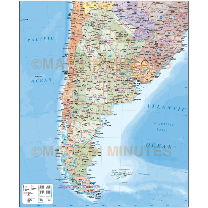
Argentina Political Road/Rail Map (including internal 1st level divisions) plus land & sea contours at 1:4,000,000 scale. This map can also be used as a Southern South America map
Layers include: Coastlines and islands, country and first level boundaries, country and first level fills (as separate objects), capital cities, major settlements (layered by population), roads, railways, country names, island names, sea/ocean names, rivers, major lakes, salt lakes, marshland and other water features, physical features, mountain ranges, spot heights, land contours, ocean floor contours plus latitude/longitude.
Formats: Choose from Illustrator CS (for use with Illustrator CS1 to CS6 or later) or, coming soon, Adobe Acrobat Editable PDF 6.0 format. Our maps in PDF 6.0 format are fully layered within Acrobat but can still be opened and edited in Illustrator CS4 -CS6 while retaining full layering with 100% editability.
Map dimensions: 20" D x 16.36" W (50.82cm D x 41.56cm W)
Extracted Document sizes: Illustrator CS: 26.6Mb Acrobat PDF: N/A
Licence: Please click on the Licence tab to download and print the lifelong licence for this product.
How to download: You will be able to download by logging into Your Account where you can check the status and details of orders (including the applicable Product End User Licence). You can download product purchases for a period of 10 days from date of purchase.
Please note: Product purchases and invoices are downloadable only and are not sent to any postal address
Authors notes: This map is new for 2014, it is one of our new maps created in association with Collins Bartholomew. This is a complete map of Argentina as you can choose so many ways to present this map, from a simple outline to a complex poster size map. Suitable for use from A4 up to A2+ size. If you would prefer to purchase a set of Regions or World maps please visit our World Maps Collections category.
| Licence | Lifelong |
|---|