Globe 40N 100E. 4-colour, multi-layered Photoshop format with a set of masks
£30.00
In stock
SKU
GeoGlobeN40E100psd
Product code: 529
Relief Globe in Photoshop layered format. Large images, Size width/height 28cm (11 inches) @ 300 dpi resolution.
Geo-Globes gives you accurate print resolution maps, specially compiled and designed for easy customising by the graphics, publishing and media industries.
Perfect for book covers, atlas pages, airline maps, globe locations, web maps, multi-media and Power-Point presentations, exhibitions and illustrations.
Already used by some of the worlds leading publishers.
As well as rivers, lakes,borders, bathymetry and graticules - just look at these unique features.
- Larger images, (and therefore higher resolution) than anything else on the market.
- At 300 DPI each image is 11 inches wide, (28cm approx).
- Unique digital height masks included with every image, for customising the relief enhancement.
- Six different colourings.
- 100,000 or more combinations as standard.
- Created by internationally renowned cartographers.
- All images entirely royalty free.
Each of the globes in this set has been designed with professional designers in mind embodying the highest cartographic standards.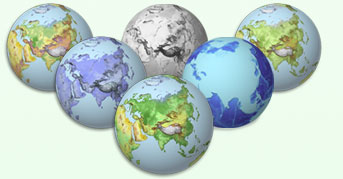 Changing colours to one of the six standards is as simple as clicking the mouse.
Unlike other products Geo-Globes are constructed digitally, and therefore are coloured accurately according to height and terrain type.
Although these documents are RGB for use with on screen presentations all colours have been tabulated to correspond with reproducible CMYK colours. From start to finish this is a professional product created by professional cartographers.
If however the colours provided are not suitable for the job required, the system allows you to quickly generate your own.
- Special Effects
One of the amazing and unique features of Geo-Globes is the inclusion of the"Height Mask". This, used in conjunction with Adobe Photoshop's Lighting filter, allows the user to give extra 3d realism to the land or even create their own relief images from scratch.
After satisfactorily creating the globe of your choice why not go one step further and add photographic lens flares, include the sun or even add clouds. Just one or two of the endless extensions you can make to Geo-Globes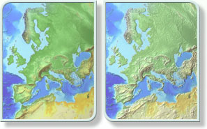
- Technical Information
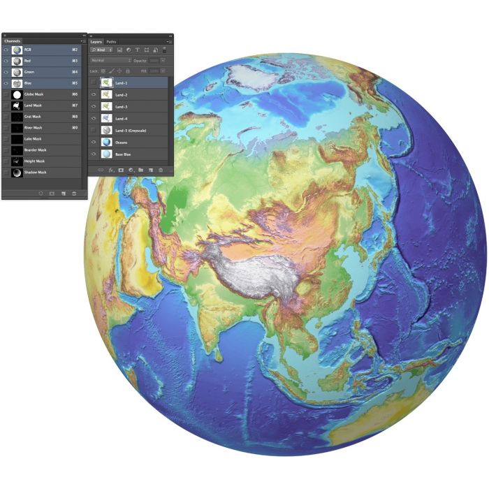
- Geo-Globes comprises a series of 19 individual elements including channel masks, layers and documents, designed to give hundreds of thousands of combinations, sufficient to satisfy even the most demanding design studio or publisher. And yet there is more. By manipulating the standard set in Adobe Photoshop the range of combinations runs into billions.
Size / Scale
Geo-Globes has been constructed for the professional user.
At 300dpi, the 10.8" (27.6cm) high resolution images are at a scale of 1:46,000,000
When converted to 150dpi, the 21.6" (55.2cm) medium resolution images are at a scale of 1:23,000,000.
And at screen resolution, 72dpi, the images are 45.26" (1.15metres) wide and at a scale of 1:11,000,000.
Document contents
Each Photoshop document contains 8 mask channels (Graticules, Lakes, Rivers, Boarders, Land, Globe and Shadow) as well as 7 Colour Layers (Land Colours 1, 2, 3, 4, 5(Greyscale), Ocean Relief and Blue Globe).
Minimum requirements
Adobe Photoshop 5.5 or above
Minimum of 128Mb ram (512Mb + Recommended)
Please note that Photoshop's Lighting Effects Filter requires physical memory and as such may not work with 128Mb ram
Document sizes
Each document is 40.6cm by 30.5cm (16x12 Inches).
File sizes vary depending on land coverage (avg. 83Mb)
| Licence | Lifelong |
|---|