Gall World Political Vector plus Relief Map Light colouring
Special Price
£130.00
Regular Price
£175.00
In stock
SKU
GallRelLight25MCS
Product code: 382
World Relief map in Illustrator format with Light coloured placed relief background. Fully layered Illustrator file 100% editable. Layers include country names, sea/ocean names, island names, river names, physical names, capital cities, major settlements, coastlines, country boundaries, latitude/longitude @ 5 and 10 degrees, major lakes, majo
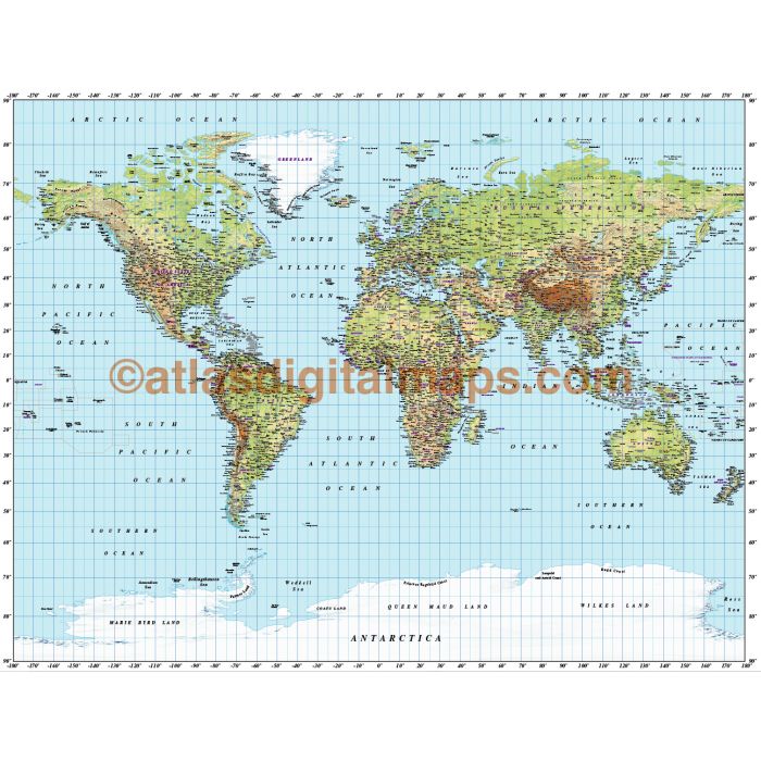
World Relief map in Illustrator format with Light coloured placed relief background. Fully layered Illustrator file 100% editable. Layers include country names, sea/ocean names, island names, river names, physical names, capital cities, major settlements, coastlines, country boundaries, latitude/longitude @ 5 and 10 degrees, major lakes, major rivers, country fills and a sea mask for colouring the sea areas. Map size 55.6 inches wide by 42.8 inches deep (141.22cm x 108.7cm). High resolution placed raster background @ 288 dpi. Suitable for use up to A2.
World Relief map in Illustrator format with Light coloured placed relief background. Fully layered Illustrator file 100% editable. Layers include country names, sea/ocean names, island names, river names, physical names, capital cities, major settlements, coastlines, country boundaries, latitude/longitude @ 5 and 10 degrees, major lakes, major rivers, country fills and a sea mask for colouring the sea areas. Map size 55.6 inches wide by 42.8 inches deep (141.22cm x 108.7cm). High resolution placed raster background @ 288 dpi. Suitable for use up to A2.
World Relief map in Illustrator format with Light coloured placed relief background. Fully layered Illustrator file 100% editable. Layers include country names, sea/ocean names, island names, river names, physical names, capital cities, major settlements, coastlines, country boundaries, latitude/longitude @ 5 and 10 degrees, major lakes, major rivers, country fills and a sea mask for colouring the sea areas. Map size 55.6 inches wide by 42.8 inches deep (141.22cm x 108.7cm). High resolution placed raster background @ 288 dpi. Suitable for use up to A2.
| Licence | Lifelong |
|---|