Gall Orthographic Projection Political World Map (UK centric), large size
ROYALTY FREE Large, very accurate, 100% editable World vector map in Illustrator format. You can choose which layers are required and turn on or off, customise all map elements, lines, fills and editable font text. Use it as is or add other information to create your own image.
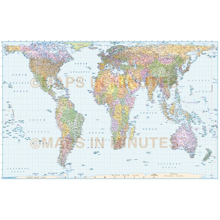
Gall Orthographic Projection Political World Map (UK Centric) @20m scale
Fully editable large scale World map in a choice of vector formats.
Layers include: Coastlines and islands, country .borders & fills, country names, sea/ocean names, rivers, major/minor lakes, river names, physical names, capital cities plus over 3400 settlements, major airports plus latitude/longitude @ 10, 5 & 1 degree intervals Includes first level borders and fills for Australia, Brazil, Canada, China, India, Russia and the United States.
Formats: Choose from Illustrator CS6 (for use with Illustrator CC or later) or Adobe Acrobat Editable PDF 6.0 format (available on request. Our maps in PDF 6.0 format are fully layered within Acrobat but can still be opened and edited in Illustrator CS4 -CS6 while retaining full layering with 100% editability.
Map dimensions: 70.92" D x 111.43" W (180.2cm D x 283.1cm W).
Extracted Document sizes: Illustrator CS: 46.5Mb Acrobat PDF: On request
Licence: Please click on the Licence tab to download and print the lifelong licence for this product.
How to download: You will be able to download by logging into Your Account where you can check the status and details of orders (including applicable Product End User Licence). You can download product purchases for a period of 10 days from date of purchase.
Please note: Product purchases and invoices are downloadable only and are not sent to any postal address
Authors notes: Suitable for whole map output from A2 up to any size. Ideal for large wall murals. 2021 updates.
An equal area projection (correctly representing areas of the sphere on the map) ideal for graphic display of specific themes such as distribution of population, resources, vegetation or industrial activity. Chosen by several religious bodies and organizations involved in Third World development (including United Nations and OXFAM). Devised in 1855 and identical to Peters Projection (devised in 1967), the Gall Orthographic is also referred to as Gall-Peters Projection - for further information please click HERE.
This map can be ordered in printed format, please contact us.
| Licence | Lifelong |
|---|