Tanzania Deluxe Map 1st level Political with Road/Rail plus land & ocean floor contours, 1:7,500,000 scale
Use as is, add other information or just create your own image.
One of the new range of maps created by us from the extensive Collins Bartholomew library.
These vector maps are available exclusively from atlas digital maps.
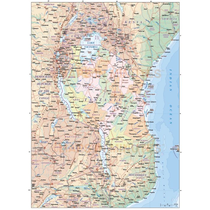
Tanzania deluxe vector map with 1st level internal divisions, country fills plus land and ocean floor contours
Fully layered, 100% editable, high resolution, 1st level complete political, road, rail and contour map of Tanzania at 1:7,500,000 scale. Suitable for use from A4+ to virtually any size, being vector based it will always print to the highest quality. All text is editable font text.
Layers include: Country/first level boundaries and fills as separate objects for Tanzania and surrounding countries, roads and railways, settlements layered by population, rivers & lakes, urban areas, physical features, mountain ranges, layered contours for
land and ocean floor, river names, lake names, island names etc. Some of the text also has outline layer options which can be
used in order to improve text print clarity. Also comes with an inset world position map and key boxes.
Technical Info/Formats: Available in Illustrator CS (for use with Illustrator CS1 to CS6 or later).
Map dimensions: 13.12" D x 9.54" W (33.35cm D x 24cm W)
Extracted Document sizes: Illustrator CS: 13.6Mb Acrobat PDF: N/A
Licence: Please click on the Licence tab to download and print the lifelong licence for this product.
How to download: You will be able to download by logging into Your Account where you can check the status and details of orders (including the applicable Product End User Licence). You can download product purchases for a period of 10 days from
date of purchase.
Please note: Product purchases and invoices are downloadable only and are not sent to any postal address
Authors notes: New for 2014 this superb deluxe Tanzania map has it all. Use for simple country maps, political map showing internal divisions or as a contour map. Complete with road and rail layers this map is from our new range of country and regional mapping sourced from the Collins Bartholomew map library. There are other map purchase options for Tanzania with varying
levels of detail.
We will be adding many more country maps in this style over the coming few months but if you have a particular country map request please contact us to see if we can help you to find the map you require.
| Licence | Lifelong |
|---|