4M scale British Isles Regular Contour Relief map (Conical Projection)
Royalty free, small scale, fully layered, 100% editable British Isles Regular contour Relief map @4,000,000 scale. Available in a choice of either Illustrator CS1 or editable PDF formats. Placed (linked) tiff regular contour colour relief background at 300dpi. EZRead text is editable font text.
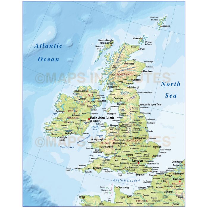
British Isles EZRead Country Map @4m scale with a 300dpi Regular contour colour relief background
Small scale, up-to-date, detailed, 100% editable layered vector map. Suitable for use from A4 to A3. All EZRead text is editable font text. Projection does not match Ordnance Survey data and co-ordinates. Contains Country boundaries and fills so can be used as either a political map, a relief map or a combination of both.
Layers include: Coastlines, country boundaries, capital cities and major settlements. Physical features include rivers, lakes, island names, mountain ranges, bay and headland names. Product includes a high resolution 300dpi relief background in regular contour colours as a placed (linked) tiff .
Formats: Available in Illustrator CS1 (for use with Illustrator CS1 to CS6 or later) or Adobe Acrobat Editable PDF 6.0 format. Our maps in PDF 6.0 format are fully layered within Acrobat but can still be opened and edited in Illustrator CS4 -CS6 while retaining full layering with 100% editability. Our relief tiff files are single layer.
Map dimensions: 14.19" D x 11.19" W (36.0cm D x 28.43cm W)
Extracted Document sizes: Illustrator CS: 4.5Mb plus 26.4Mb placed relief background tiff file Acrobat PDF: 26.2Mb with embedded relief background tiff file
Licence: Please click on the Licence tab to download and print the lifelong licence for this product.
How to download: You will be able to download by logging into Your Account where you can check the status and details of orders (including the applicable Product End User Licence). You can download product purchases for a period of 10 days from date of purchase. This is a large file so may take a while to download.
Please note: Product purchases and invoices are downloadable only and are not sent to any postal address
Authors notes: This quality map is updated for 2013. It is in Lamberts Conical projection which will not match Ordnance Survey co-ordinates and data. Buy today and use immediately. Also available are sets of British Isles maps, please see our British Isles Map Collections category.
| Licence | Lifelong |
|---|