Gall Projection French World Map (UK centric) @20m scale Style 2
ROYALTY FREE. Large scale French language World map with capital cities and major cities. Very accurate, 100% editable in Illustrator and PDF vector formats. Customise all map elements, lines, fills and editable font text. Use as is or add other information to create your own image. This is a high quality detailed digital vector map.
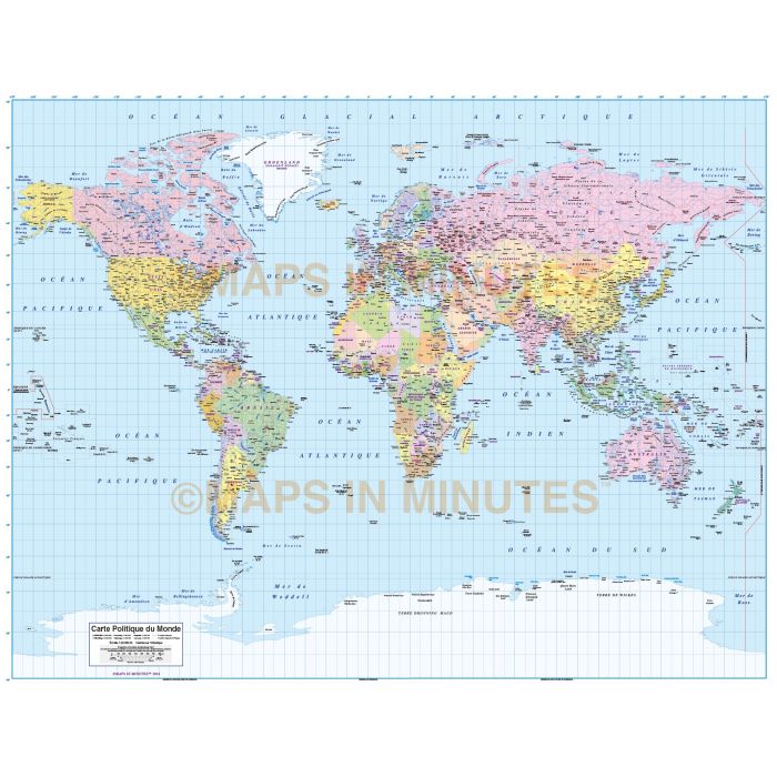
Gall Projection french language World Map (UK centric) @1:20,000,000 scale
Digital vector map in french. Fully editable large scale World map in Illustrator format.
Layers include: Coastlines and islands, country borders & fills, country names, sea/ocean names, rivers, major/minor lakes, river names, lake names, physical names, capital cities plus over 3400 settlements, major airports, Sea contours plus latitude/longitude @ 10, 5 & 1 degree intervals. Includes first level borders and fills for Australia, Brazil, Canada, China, India, Russia and the United States.
Formats: Choose from Illustrator CS (for use with Illustrator CS1 to CS6 or later) or Adobe Acrobat Editable PDF 6.0 format. Our maps in PDF 6.0 format are fully layered within Acrobat but can still be opened and edited in Illustrator CS4 -CS6 while retaining full layering with 100% editability.
Map dimensions: 24" D x 32" W (62.5cm D x 81.4cm W)
Extracted Document sizes: Illustrator CS: 70Mb
Licence: Please click on the Licence tab to download and print the lifelong licence for this product.
How to download: You will be able to download by logging into Your Account where you can check the status and details of orders (including the applicable Product End User Licence). You can download product purchases for a period of 10 days from date of purchase.
Please note: Product purchases and invoices are downloadable only and are not sent to any postal address
Authors notes: This map is updated for 2014 including newly created South Sudan. Suitable for use up to any size but if using the whole map it is not suitable for under A3 due to the amount of detail. Useful to be able to crop any area/region of the world or when you just need a very large map. If you would prefer to purchase a set of world maps please visit our World Map Collections category.
| Licence | Lifelong |
|---|