British Isles 500,000 scale Full Deluxe Map Collection
The ultimate set of British Isles maps from A5 to any size. British Isles vector map collection @1m, 5m and 500k scale including Relief backgrounds. Complete British Isles maps and regional sections. Up-to-date, very accurate, 100% editable and fully layered in Adobe Illustrator. You can choose which layers you require and turn them on or off, customise all the map elements, lines, fills and editable font text. Use as is, add other information or just create your own image.
This collection is being prepared for uploading and will be up for sale again shortly.
Please Contact Us for details or to purchase.
UPDATED TO 2014 DATA, ANNUAL LICENCE. This is truly a complete British Isles mapping package. British Isles Full Deluxe Map Collection @5m, 1m and 500k scale plus relief backgound options. 100% editable and fully layered in Adobe Illustrator CS4 format for use up to CS6 or later. Illustrator CS6 (or Cloud) is our suggestion and preference for using this set.
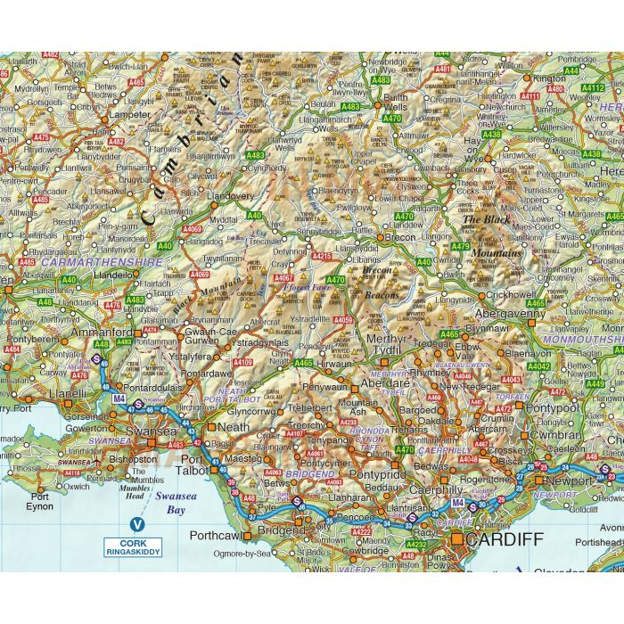
Layers include (dependent on the map) Roads (Primary routes, 'A' roads, 'B' Roads, minor and C road selection and Motorways), M'way junctions, M'way juction numbers, Service stations & Services names, Railways, Airports, Extra Settlements, Rivers & Lakes, vector Sea masks, County/Region/Administrative boundaries and fills, Physical features (Mountain ranges, spot heights, river names, lake names, island names etc.). Inset maps are also supplied for the Northern isles of Shetland and Orkney.
Product contains the following complete maps:
British Isles County, Road, Rail and Relief map @500,000 scale,
British Isles County, Road, Rail and Relief map @1,000,000 scale,
British Isles County, Road, Rail and Relief map at @5,000,000 scale
Product also contains the following section @1:500,000 scale maps:
Scotland map, North England map, Central England, East England map, South East England map, South West England map, Wales map and Ireland map plus Inset maps of the Northern Isles of Shetland and Orkney.
All complete maps and all section maps include regular colour relief backgounds.
| Licence | Annual |
|---|