Detailed South East England Map, Illustrator AI vector, Road, Rail & County, large 750k scale 2018
Large, up-to-date 2018, highly detailed, South East England Map, vector county, road and rail map in AI Illustrator CS and PDF formats. Use up to any size. Editable font text. Matches Ordnance Survey data. Contains boundaries and fills. 750k scale.
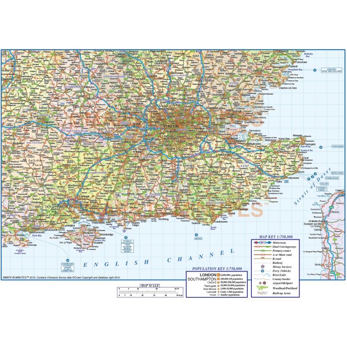
South East England map, Road, Rail and County, Illustrator AI CS vector format, detailed 750k scale
Large up-to-date, highly detailed, 100% editable layered vector map. Suitable for use up to any size. All text is editable font text. Projection matches Ordnance Survey data and co-ordinates. Contains 1st level county boundaries and fills so can be used as either a political map, a road & rail map or a combination of both.
Layers include: Coastlines, county boundaries, county fills (as separate objects). Settlements layered by population. Road layers include Motorways (plus m/way junctions, junction numbers, service stations and names) Primary routes and 'A' roads (including dual carriageways)), B roads, comprehensive layered road numbering, railways, airports and airport names. Physical features include urban areas, forest and woodland, rivers and river names, lakes and lake names, island, bay and headland names.
Formats: Available Illustrator CS5, CS6 (for use with Illustrator CC) or Adobe Acrobat Editable PDF 6.0 format. Our maps in PDF 6.0 format are fully layered within Acrobat but can still be opened and edited in Illustrator CS4 -CS6 while retaining full layering with 100% editability.
Map dimensions: 7.63" D x 11.4" W (19.38cm D x 28.96cm)
Extracted Document sizes: Illustrator CS: 42.5Mb uncompressed
Licence: Please click on the Licence tab to download and print the lifelong licence for this product.
How to download: You will be able to download by logging into Your Account where you can check the status and details of orders (including the applicable Product End User Licence). You can download product purchases for a period of 10 days from date of purchase. Time taken to download will depend on your Broadband speed.
Please note: Product purchases and invoices are downloadable only and are not sent to any postal address
Authors notes: This great map has been completely re-drawn for 2018. We do not just export GIS data to Illustrator and sell it on, we hand draw every line and carefully place every piece of text. It is very accurate having been drawn using Ordnance Survey data and the area coverage has been increased over the previous South East England edition. All coastlines, boundaries, rivers and lakes are also now at a much greater detail than any previous editions.
| Licence | Lifelong |
|---|