Caribbean small scale light colour Relief map
Royalty free relief map of the caribbean. Data includes coastlines, borders, capital cities and major settlements, island names and vector sea mask (for easy changes to sea colour). Includes a placed (linked) tiff file showing relief in light colours. Available in Illustrator CS.
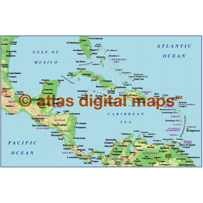
Caribbean relief map with light colour land relief @50,000,000 scale
A low resolution 300dpi light Land relief map. Fully editable, layered small scale map in Illustrator format.
Layers include: Coastlines, country boundaries, capital cities, major settlements, country names, sea/ocean names, rivers, major lakes.
Formats: Choose from Illustrator CS (for use with Illustrator CS1 to CS6 or later) or coming soon, Adobe Acrobat Editable PDF 6.0 format. Our maps in PDF 6.0 format are fully layered within Acrobat but can still be opened and edited in Illustrator CS4 -CS6 while retaining full layering with 100% editability.
Map dimensions: xx" D x xx" W (xxcm D x xxcm W)
Extracted Document sizes: Illustrator CS: xxMb Acrobat PDF: n/a
Licence: Please click on the Licence tab to download and print the lifelong licence for this product.
How to download: You will be able to download by logging into Your Account where you can check the status and details of orders (including the applicable Product End User Licence). You can download product purchases for a period of 10 days from date of purchase.
Please note: Product purchases and invoices are downloadable only and are not sent to any postal address
Authors notes: This map is updated for 2013. Suitable for use around A4 size. If you would prefer to purchase a set of Regions or World maps please visit our World Maps Collections category.
| Licence | Lifelong |
|---|