Detailed British Isles UK Road and Rail map, Illustrator AI CS vector format, counties, large 750k scale
Large, up-to-date, layered British Isles UK road, rail & county map in Illustrator digital format.
Contains county/admin boundaries and fills. This product is under an annual licence.
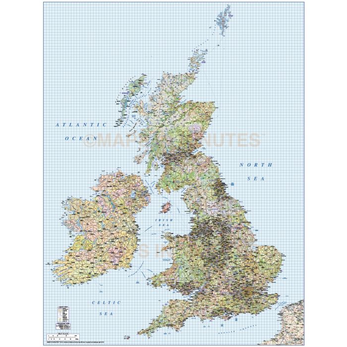
British Isles UK Political Road and Rail Map, Illustrator AI CS vector format. 750k scale with the Northern Isles of Orkney & Shetland in position
Fully layered, 100% editable high resolution 1st level complete county road/rail map of the British Isles. Suitable for use from A2 to virtually any size, being vector based it will always print to the highest quality. Matches Ordnance Survey data and co-ordinates. This product is under an annual licence.
Layers include: Coastlines, county boundaries, county fills (as separate objects). Settlements layered by population. Road layers include Motorways (including m,way junctions, junction numbers and service stations & names) Primary routes and 'A' roads (including dual carriageways)), 'B' roads, comprehensive road numbering, railways, airports and airport names. Physical features include urban areas, forest and woodland, rivers and river names, lakes and lake names, mountain ranges, island names, bay and headland names.
Formats: Available Illustrator CS4 (for use with Illustrator CS4 to CS6 or later).
Map dimensions: 49.11" D x 37.45" W (124.74cm D x 95.13cm W)
Extracted Document sizes: Illustrator CS: 178.1Mb
Licence: Please click on the Licence tab to download and print the Annual licence for this product.
How to download: You will be able to download by logging into Your Account where you can check the status and details of orders (including the applicable Product End User Licence). You can download product purchases for a period of 10 days from date of purchase. Time to download will depend on your Broadband speed.
Please note: Product purchases and invoices are downloadable only and are not sent to any postal address
Authors notes: This stunning map is re-drawn and updated for 2017 and is some of the most highly detailed editable mapping available off the shelf. You could commision someone to create this map for you, but not for this price and not today. It will match Ordnance Survey co-ordinates and data. We believe this is the best British Isles mapping you can buy today and use immediately. Also available for purchase are sets of British Isles maps, please see our British Isles Map Collections category.
If you would like a custom map created to your requirements please Contact Us for a quote or give us a call to discuss.
| Licence | Annual |
|---|