5M scale British Isles County Road map with Medium colour Relief
Royalty free, British Isles Road and Political map with Medium colour Relief @5,000,000 scale (Relief background @300dpi), suitable for use from A3 to A2+. 100% editable and fully layered in either Adobe Illustrator CS or Editable PDF formats.
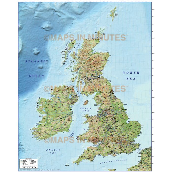
British Isles County Road Relief Map @5m scale with a 300dpi Medium colour relief background
Large scale, up-to-date, detailed, 100% editable layered vector map. Suitable for use from A3 up to almost any size. All text is editable font text. Projection matches Ordnance Survey data and co-ordinates. Contains Country boundaries and fills so can be used as either a political map, a relief map or a combination of both.
Layers include: Coastlines, county boundaries, county fills (as separate objects). Settlements layered by population. Road layers include Motorways, Primary routes and 'A' roads (including dual carriageways)), comprehensive road numbering, railways, airports and airport names. Physical features include rivers and river names, lakes and lake names, mountain ranges, island names, bay and headland names. Product includes a high resolution 300dpi relief background in medium colours as a placed (linked) tiff .
Formats: Available in Illustrator CS1 (for use with Illustrator CS1 to CS6 or later) or Adobe Acrobat Editable PDF 6.0 format. Our maps in PDF 6.0 format are fully layered within Acrobat but can still be opened and edited in Illustrator CS4 -CS6 while retaining full layering with 100% editability. Our relief tiff files are single layer.
Map dimensions: 10.06" D x 7.9" W (25.26cm D x 20.11cm W)
Extracted Document sizes: Illustrator CS: 34.4Mb plus 21.6Mb placed relief background tiff file Acrobat PDF: XXMb with embedded relief background tiff file
Licence: Please click on the Licence tab to download and print the lifelong licence for this product.
How to download: You will be able to download by logging into Your Account where you can check the status and details of orders (including the applicable Product End User Licence). You can download product purchases for a period of 10 days from date of purchase. This is a large file so may take a while to download.
Please note: Product purchases and invoices are downloadable only and are not sent to any postal address
Authors notes: This quality map is new for 2013 and is the most highly detailed editable small scale mapping available off-the-shelf. Our relief backgounds are brand new and have the highest detail we have ever offered. It will match Ordnance Survey co-ordinates and data. Buy today and use immediately. Also available are sets of British Isles maps, please see our British Isles Map Collections category.
| Licence | Lifelong |
|---|