East England County Road and Rail Map with hill shading @1m scale
How do you make a County map more interesting? Answer...add a hill shading layer. Large, up-to-date, highly detailed, 100% editable vector county road and rail map with shaded relief option in Illustrator and PDF formats.
Suitable for use up to any size. All text is editable font text. Projection will match OS data and co-ordinates. Contains 1st level admin boundaries and fills so can be used as either a county map, a road map, a combination of both and now with a simple relief option.
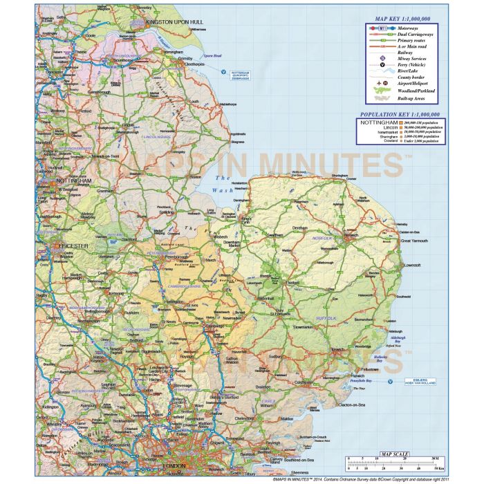
East England 1st level County, Road & Rail Map with shaded relief layer option @1,000,000 scale
Large up-to-date, highly detailed, 100% editable layered vector map. Suitable for use up to any size. All text is editable font text. Projection will match Ordnance Survey data and co-ordinates. Contains 1st level admin boundaries and fills so can be used as either a political map, a road and rail map. Now with the addition of a 300dpi shaded relief layer to give texture to a county map. Adding subtle relief information without having to add a full colour relief background.
Layers include: Coastlines, county boundaries, county fills (as separate objects). Settlements layered by population. Road layers include Motorways (including motorway junctions and service stations) Primary routes and 'A' roads (including dual carriageways)), comprehensive road numbering, railways, airports and airport names. Physical features include urban areas, forest and woodland, rivers and river names, lakes and lake names, island, bay and headland names. Plus the 300dpi shaded relief tiff file layer.
Formats: Available Illustrator CS1 (for use with Illustrator CS1 to CS6 or later).
Map dimensions: 9.1"wide x 10.4"deep (23.13cm x 26.41cm)
Extracted Document sizes: Illustrator CS: xxMb plus a 7.8Mb greyscale shaded relief tiff Acrobat PDF: N/a
Licence: Please click on the Licence tab to download and print the lifelong licence for this product.
How to download: You will be able to download by logging into Your Account where you can check the status and details of orders (including the applicable Product End User Licence). You can download product purchases for a period of 10 days from date of purchase. This is a large file so may take a while to download.
Please note: Product purchases and invoices are downloadable only and are not sent to any postal address
Authors notes: This map has been completely re-drawn for 2014 and the shaded relief is new. We hand draw every line and carefully place every piece of text. It is very accurate mapping having been drawn mainly based on Ordnance Survey data and the area coverage has been increased over all previous East England editions. All coastlines, boundaries, roads, railways, rivers, lakes etc. are also now at a much greater detail than any previous editions.
Also available for purchase are sets of British Isles map sections, please see our British Isles Map Collections category.
If you would like a relief map created to your custom boundaries this can be ordered. Please Contact Us for a quote or give us a call to discuss.
| Licence | Lifelong |
|---|