Equirectangular Political World Map with insets UK centric @20M scale
ROYALTY FREE Large, very accurate, 100% editable World vector map in Illustrator format. You can choose which layers are required and turn on or off, customise all map elements, lines, fills and editable font text. Use as is or add other information to create your own image.
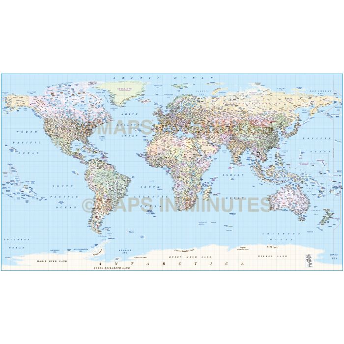
Equirectangular Projection Political World map with Country/State insets (UK centric) @20m scale
One of our most popular World maps just got better. Fully editable large scale World map in a choice of vector formats. Capital cities and settlements are now layered by population giving you greater control.
Layers include: Coastlines and islands, country borders & fills, country names, sea/ocean names, rivers, major/minor lakes, river names, lake names, physical names, capital cities plus over 3000 settlements layered by population, latitude/longitude @ 10 & 5 degree intervals. Includes first level borders and fills for Australia, Brazil, Canada, China, India, Russia and the United States.
Technical Info/Formats: Illustrator CS6 (for use with Illustrator CS6 to CC or later) or Adobe Acrobat Editable PDF 6.0 format (on request). Our maps in PDF 6.0 format are fully layered within Acrobat but can still be opened and edited in Illustrator CS6 while retaining full layering with 100% editability.
Map dimensions: Map dimensions 39.4" D x 68.27" W (100cm x 173.4cm.)
Extracted Document sizes: Illustrator CS: 35.5Mb Acrobat PDF: On request
How to download: You will be able to download by logging into Your Account where you can check the status and details of orders (including the applicable Product End User Licence). You can download product purchases for a period of 10 days from date of purchase.
Please note: Product purchases and invoices are downloadable only and are not sent to any postal address
Authors notes: This map is updated and re-styled for 2021. Suitable for use up to any size. The re-layerering of the settlements gives better control for the user to customise. These maps are used to print our wall murals which gives an indication of maximum size usage. If using the whole map it is not suitable for under A2 due to the amount of detail. Useful to be able to crop any area/region of the world or when you just need a very large high quality map. This map is also available as a printed map (Product Code no. 70).
For more information or to licence this image, please Contact Us
| Licence | Lifelong |
|---|