Gall Large World Political and Natural Earth Relief Map
World digital vector relief map in Illustrator format with a high resolution Natural Earth linked relief background at 300dpi. Fully layered file 100% editable. This is a large map, for use preferably in Illustrator CS6 or later.
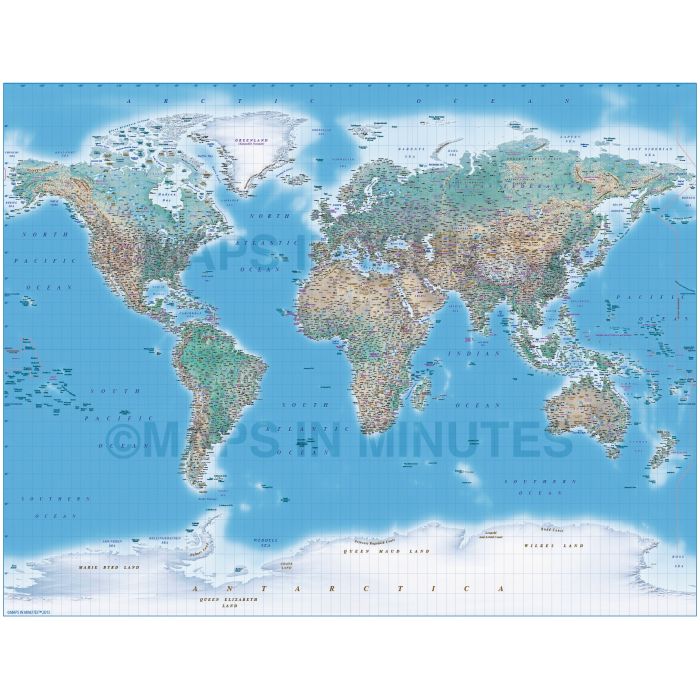
Gall Projection large scale vector map plus Natural Earth Relief background (UK centric)
Fully editable large scale Illustrator format political map of the World in the Gall projection with high quality Natural Earth relief tiff background option. This map has been printed 3-4m with superb results. Popular for Travel Companies, Boardrooms and offices, schools, Television and Movies. Anywhere you need an informative map that makes a big impression. This is a beautiful map
Illustrator layers include: Country names, sea/ocean feature names, rivers, major/minor lakes, river names, lake names, island names, physical names, capital cities (2 sets...one all the same size and a second set layer by population) plus over 3500 settlements (layered by population), major airports plus latitude/longitude @ 10, 5 & 1 degree intervals. Includes first level borders of Australia, Brazil, Canada, China, India, Russia and the United States. 300dpi tiff format linked relief background for land plus ocean floor.
Formats: Choose from Illustrator CS4, CS5 or CS6/CC.
Map dimensions: 42.9" D x 55.72" W (109cm D x 141cm W)
Extracted Document sizes: Illustrator CS: 85Mb plus Tiff format relief: 330Mb linked 300dpi background.
Licence: Please click on the Licence tab to download and print the lifelong licence for this product.
How to download: You will be able to download by logging in to Your Account where you can check the status and details of orders (including applicable Product End User Licence). You can download product purchases for a period of 10 days from date of purchase.
Please note: Product purchases and invoices are downloadable only and are not sent to any postal address
Authors notes: This stunning map is updated and ready for 2016. Suitable for A2 up to almost any size. These digital maps are used to print our giant wall murals which gives an indication of maximum size usage. This detail is so good regions can easily be cropped for use. If you would prefer to purchase a set of world maps please visit our Map Collections category.
| Licence | Lifelong |
|---|