North England County Road & Rail map with Regular colour relief @1m scale
Large scale, up-to-date, highly detailed, 100% editable layered vector political and relief map in Illustrator CS format. Suitable for use up to almost any size. All text is editable font text. Projection will match Ordnance Survey data and grid co-ordinates.
Contains county/administrative boundaries so can be used as either a political county map, a relief map, a road map or a combination of any.
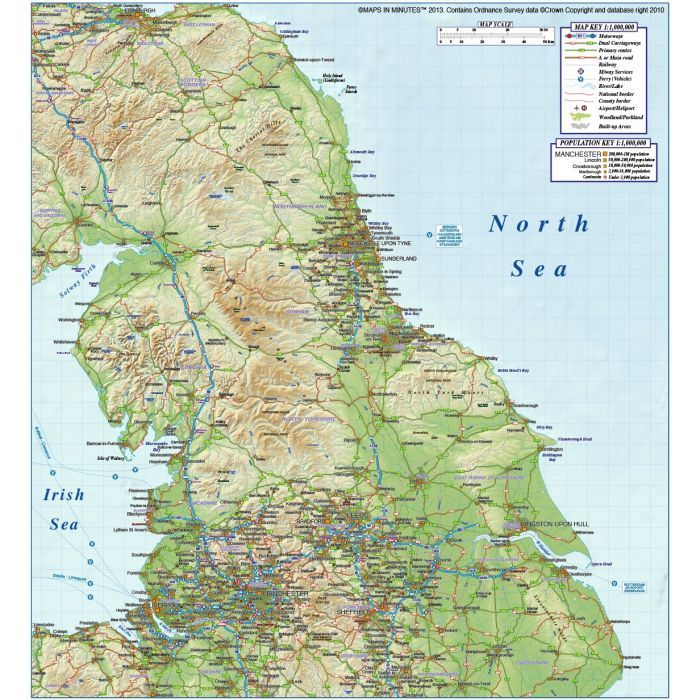
North England County, Road & Rail Map @1,000,000 scale with a 300dpi Regular colour relief background
Large scale, up-to-date, highly detailed, 100% editable layered vector map. Suitable for use up to virtually any size. All elements on the map can be easily altered and all text is editable font text. Matches Ordnance Survey projection and co-ordinates. Contains 1st level administrative boundaries and fills so can be used as a political map, a relief map or a combination of either.
Layers include: Coastlines, county boundaries, county fills (as separate objects). Settlements layered by population. Road layers include Motorways (including motorway junctions and service stations) Primary routes and 'A' roads (including dual carriageways)), comprehensive road numbering, railways, airports and airport names. Physical features include urban areas, forest and woodland, rivers and river names, lakes and lake names, island, bay and headland names, spot heights and symbols. Product also includes a high resolution 300dpi relief background in regular colours as a placed (linked) tiff.
Formats: Available in Illustrator CS1 (for use with Illustrator CS1 to CS6 or later) or Adobe Acrobat Editable PDF 6.0 format. Our maps in PDF 6.0 format are fully layered within Acrobat but can still be opened and edited in Illustrator CS4 -CS6 while retaining full layering with 100% editability. Our relief tiff files are single layer.
Map dimensions: 12.87" D x 11.8" W (32.7cm D x 29.9cm W)
Extracted Document sizes: Illustrator CS: 4.5Mb plus 26.4Mb placed relief background tiff file Acrobat PDF: 26.2Mb with embedded relief background tiff file
Licence: Please click on the Licence tab to download and print the lifelong licence for this product.
How to download: You will be able to download by logging into Your Account where you can check the status and details of orders (including the applicable Product End User Licence). You can download product purchases for a period of 10 days from date of purchase. This is a large file so may take a while to download.
Please note: Product purchases and invoices are downloadable only and are not sent to any postal address
Authors notes: This stunning map is re-drawn and updated for 2013 and is the most highly detailed editable mapping available off the shelf. These are new 300dpi relief backgrounds with a fantastic level of detail. You could commision someone to create this map for you, but not for this price and not today. Buy today and use immediately. Also available for purchase are sets of British Isles maps, please see our British Isles Map Collections category.
If you would like a custom map created to your requirements please Contact Us for a quote or give us a call to discuss.
| Licence | Lifelong |
|---|