Gall Political World Map with insets & Ocean floor contours US centric
Large, extra detail, accurate, 100% editable World vector map in Illustrator CSformat.
Customise all map elements, lines, fills and editable font text.
The detail on this map has been specifically designed for use at a large size or to custom crop. Highly legible typographic design makes this map stand out and easy to read.
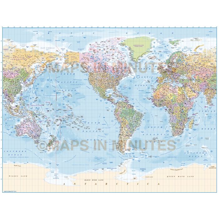
Gall Projection, large scale, Political World vector map with country insets and ocean floor contours,
Americas centric @10,000,000 scale
Fully editable large scale World map you can use or print up to any size, in a choice of vector formats.
Layers include: Coastlines and islands, country borders & fills, country names, sea/ocean names, rivers, major/minor lakes, river names, lake names, physical names, capital cities plus over 3400 settlements, major airports, latitude/longitude @ 10 & 5 degree intervals. Includes first level borders and fills for Australia, Brazil, Canada, China, India, Russia and the United States. Ocean floor contours at -200m, -500m, -1,000m, -2,500m, -5,000m, -7,500m and -10,000m.
Formats: Choose from Illustrator CS4 (for use with Illustrator CS4 & CS5) or Illustrator CS6 (for use with Illustrator CS6 & CC or later) or Adobe Acrobat Editable PDF 6.0 format (available on request).
Our maps in PDF 6.0 format are fully layered within Acrobat but can still be opened and edited in Illustrator CS4 -CC while
retaining full layering with 100% editability.
Map dimensions: 85" D x 110" W (108.85cm D x 141.51cm W)
Extracted Document sizes: Illustrator CS: 63Mb Acrobat PDF: On request
Licence: Please click on the Licence tab to download and print the lifelong licence for this product.
How to download: You will be able to download by logging into Your Account where you can check the status and details of orders (including the applicable Product End User Licence). You can download product purchases for a period of 10 days from date of purchase.
Please note: Product purchases and invoices are downloadable only and are not sent to any postal address
Authors notes: This map is new for 2015 and includes the new Indian state of Telangana. Suitable for use up to any size. These maps are used to print our wall murals which gives an indication of maximum size usage. If using the whole map it is not suitable for under A2 due to the amount of detail. Useful to be able to crop any area/region of the world or when you just need a very large map. This is stunning quality mapping at a very reasonable cost. Check out the Aral Sea (what's left of it) to see how it looks today.
If you would prefer to purchase a set of world maps please visit our Map Collections category. Regional maps of this style have being released online this month.
| Licence | Lifelong |
|---|