British Isles County Road & Rail map @1,000,000 scale with Regular Relief
Large scale, up-to-date, highly detailed, 100% editable layered vector British Isles 1st level county & regions road map in Illustrator CS and editable PDF format. Suitable for use from A3+ up to any size. All text is editable font text. Projection matches Ordnance Survey data and co-ordinates. Contains 1st level administrative boundaries and fills so can be used as either a political map, a road/rail map, a relief map or a combination of any.
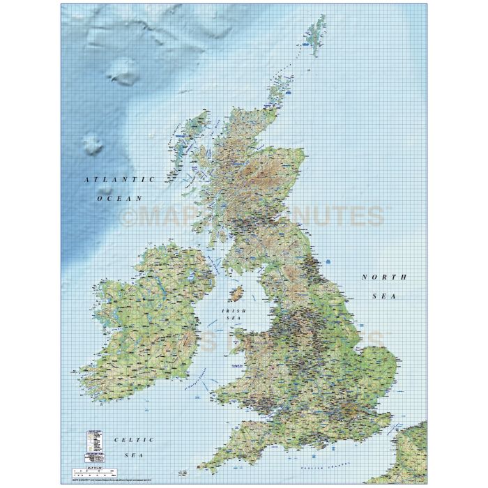
British Isles 1st level Political Road and Rail Map @1,000,000 scale with Regular colour Relief at 300dpi
Fully layered, 100% editable, high resolution, 1st level complete political road and rail map of the British Isles including the Northern Isles of Orkney and Shetland in position. Suitable for use from A3 to virtually any size, being vector based it will always print to the highest quality. Projection matches Ordnance Survey data and co-ordinates. This is British Isles mapping at its very best, a road & rail map, an administrative map, a relief map, or a combination of any.
Layers include: Coastlines, county boundaries, county fills (as separate objects). Settlements layered by population. Road layers include Motorways (including m'way junctions, junction numbers and service stations & names) Primary routes and 'A' roads (including dual carriageways)), comprehensive road numbering, railways, airports and airport names. Physical features include urban areas, forest and woodland, rivers and river names, lakes and lake names, mountain ranges, island names, bay and headland names. Includes a linked Regular relief background at 300dpi and a Sea/Land mask is supplied in tiff format allowing you to edit the relief tiff file.
Formats: Available Illustrator CS1 (for use with Illustrator CS1 to CS6 or later) or Adobe Acrobat Editable PDF 6.0 format. Our maps in PDF 6.0 format are fully layered within Acrobat but can still be opened and edited in Illustrator CS4 -CS6 while retaining full layering with 100% editability.
Map dimensions: 49.11" D x 37.45" W (124.74cm D x 95.13cm W)
Extracted Document sizes: Illustrator CS: 175.8 Mb Illustrator file plus relief file 496.7 Mb Acrobat PDF: Coming soon
Licence: Please click on the Licence tab to download and print the lifelong licence for this product.
How to download: You will be able to download by logging into Your Account where you can check the status and details of orders (including the applicable Product End User Licence). You can download product purchases for a period of 10 days from date of purchase. Time to download will depend on your Broadband speed, this is quite a large download.
Please note: Product purchases and invoices are downloadable only and are not sent to any postal address
Authors notes: This stunning map is re-drawn and updated for 2013. This is not clip art, this is mapping of the finest quality. Our perfect matching of vector to raster relief, the placement of the text for clarity, the accuracy of our roads, this level of mapping has never been offered before. Why commision someone to create this map for you, do your own and save thousands. It will match Ordnance Survey co-ordinates and data while many other UK maps sold by non-UK companies are in various conic projections and will not. Also available for purchase are sets of British Isles maps, please see our British Isles Map Collections category.
If you would like a custom map created to your requirements please Contact Us for a quote or give us a call to discuss.
| Licence | Lifelong |
|---|